Skip to content

01305 303101

hello@dronesales.co.uk

Row midpoint Shape Decorative svg added to bottom
Header-White-Stroke-Logo

Drone Store & Service Centre

vaspba-group-web-logo

7
6
4
3
1
2
  • Products
    • Beginner
      • DJI Mini 5
      • DJI Neo 2
      • DJI Mini 4
      • DJI Flip
    • Professional
      • DJI Mavic 4
      • DJI Air 3S
      • DJI Inspire 3
    • Enterprise
      • DJI Matrice 400
      • DJI Matrice 4
      • DJI Dock
      • DJI FlyCart
      • Software
    • Agricultural
      • DJI Agras T100
      • DJI Agras T25
      • DJI Agras T50
      • DJI Mavic 3M
    • FPV
      • DJI Avata 360
      • DJI Avata 2
    • Waterproof Drones
      • Splashdrone 4+
      • Fisherman (FD1+)
      • Fisherman Max (FD2)
      • Fisherman 3 (FD3)
    • Accessories
      • DJI Goggles 3
        • Aero Ping
      • Waterproof Tablet
  • Blog
  • Aeroguard
  • Contact
  • £0.00
Trustpilot

DJI Matrice 400 (M400) — Enterprise Power for UK Operations

DJI Matrice 400 delivers long endurance, weather-ready reliability, a robust enterprise link, and RTK precision. Pair it with next-gen payloads for inspections, mapping and public safety work across the UK — supplied by Drone Sales UK.

  • Rugged & weather ready: IP-rated airframe for year-round use.
  • Next-gen connectivity: O4 Enterprise link for stable command & video.
  • RTK-ready accuracy: Centimetre-class positioning with compatible bases.
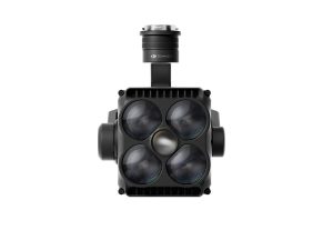
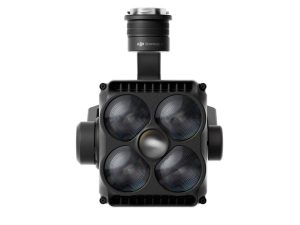
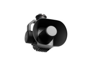
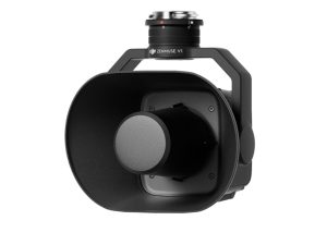
  • Flexible payloads: Works with H30, L2, P1, S1, V1.

See Drone Explore Features FAQ Spec Sheet Compare Models

Home / Enterprise Drones / DJI M400 / Page 2

Showing 13–15 of 15 resultsSorted by price: high to low

  • DJI BS100 Intelligent Battery Station

    DJI BS100 Intelligent Battery Station

    £1,150.00
    Buy Now
  • DJI Zenmuse S1

    DJI Zenmuse S1

    £1,100.00
    Buy Now
  • DJI Zenmuse V1

    DJI Zenmuse V1

    £810.00
    Buy Now
  • ←
  • 1
  • 2

DJI Matrice 400 — Advanced Enterprise Platform for UK Operations

The DJI Matrice 400 is a long-endurance, multi-role enterprise drone built for demanding inspection, mapping and public-safety missions. With advanced 3D sensing, a robust payload ecosystem and O4 Enterprise connectivity, the M400 delivers reliable performance across utilities, construction, surveying and emergency response — supported by Drone Sales UK for setup, workflow integration and UK-focused training.

Long-endurance Platform Up to ~6 kg Payload 3D LiDAR + mmWave Sensing O4 Enterprise Link IP-rated Airframe
Matrice 400 endurance operations

Mission Endurance for Bigger Sites

Optimised for long-duration operations with efficient power usage and quick battery swaps — allowing extended corridor surveys, line patrols or multi-location inspections within tight UK weather windows.

  • Optimised powertrain for stable long-flight performance
  • Fast battery changeovers support continuous workflows
  • Balanced airframe for heavier enterprise payloads

Flexible Payloads for Professional Results

Swap payloads in seconds to tailor the M400 for inspections, mapping, LiDAR capture or emergency response.

  • Multi-sensor gimbals like the H30 Series
  • LiDAR mapping via Zenmuse L2 and L3
  • Full-frame mapping using Zenmuse P1
  • Public-safety accessories: S1 spotlight, V1 loudspeaker
M400 payload options

Payload Ecosystem Highlight — Zenmuse L3

DJI Zenmuse L3

The Zenmuse L3 adds long-range LiDAR (up to 950 m), dual 100 MP RGB cameras and advanced scanning modes — ideal for forestry, utilities, elevation modelling and high-accuracy inspection workflows.

Learn More

Zenmuse H30 Series

Five-in-one payload with zoom, thermal, NIR, rangefinder and wide sensors.

Zenmuse L2

High-accuracy LiDAR with RGB camera and IMU integration.

Zenmuse P1

Full-frame photogrammetry camera with interchangeable lenses.

Zenmuse S1

High-brightness spotlight for night ops and public safety.

Zenmuse V1

Long-range loudspeaker for emergency and crowd communication.

Manifold 3

On-board AI compute module delivering up to 100 TOPS.

3D Obstacle Sensing for Power-Line Inspections

Rotating LiDAR, mmWave radar and 360° vision deliver fine-structure detection for safer utility and infrastructure flights.

  • 360° sensing coverage
  • Wire-level object detection
  • IP-rated reliability in UK conditions

O4 Enterprise Link & Airborne Relay

A stable HD control link designed for complex inspection sites and long-distance corridors.

  • Low-latency HD live view
  • High-resistance to interference
  • Relay-assisted connectivity for large sites

Automation, Repeatability & Reporting

Create precise repeatable survey paths, automated inspections and time-series datasets.

  • Waypoint, corridor & arc missions
  • Repeatable datasets for audits
  • Fast export to LiDAR & photogrammetry workflows

Built for UK Enterprise Teams

Utilities & Infrastructure

Line patrols, tower and substation inspections with zoom, thermal and LiDAR payloads.

Survey & Mapping

Corridor mapping, progress tracking and terrain modelling with repeatable accuracy.

Public Safety & Search

Thermal search, assessment and communication tools for emergency operations.

DJI Matrice 400 Gimbal Detail
Enquire Now

DJI Matrice 400 — Frequently Asked Questions

What is the DJI Matrice 400 and who is it for?›

The DJI Matrice 400 (M400) is a next-generation enterprise platform for inspections, surveying, mapping and public-safety tasks. It supports interchangeable payloads (thermal, zoom, LiDAR, photogrammetry) and adds advanced all-round obstacle sensing for safer missions.

How long can the M400 fly?›

Can be up to 59 minutes but endurance depends on payload, temperature, wind and flight profile. With light payloads and calm conditions you can expect extended flight times suitable for corridor surveys and long inspection runs. Plan conservatively and keep battery turnaround logistics ready on site.

Is the Matrice 400 weather-resistant? What’s the IP rating?›

The airframe is IP55-rated for outdoor work, offering dust and water-jet resistance. This is not a “waterproof” claim avoid heavy rain and always inspect seals, doors and gaskets after field use.

How good is obstacle sensing on the M400?›

The M400 fuses omnidirectional vision with rotating LiDAR and mmWave radar for robust 3D awareness, improving detection of slim structures such as cables and masts. Always maintain VLOS and fly with prudent margins.

Does the M400 support offline work and data security controls?›

Yes. You can operate without network connectivity and control data transfer paths. Limit log syncing, keep media on encrypted cards, and apply internal IT policies for evidence handling. For sensitive UK sites, use air-gapped workflows and documented chain-of-custody.

How do I get RTK corrections in the UK (NTRIP vs base station)?›

Most teams use an NTRIP subscription via 4G/5G on the controller for convenience. For weak signal areas or repeatable jobs, a local RTK base gives reliable, consistent corrections. Always confirm mountpoint, datum and antenna setup before flight.

What’s the best way to plan mapping missions for UK farms and estates?›
  • Fly at consistent AGL with terrain follow where needed.
  • Start around 70–80% overlap/sidelap for RGB mapping; increase in wind.
  • Use RTK and place a few check points to validate accuracy.
  • Avoid strong sun angles for uniform imagery; keep lenses clean and dry.
Can the M400 integrate with cloud platforms and live streaming?›

Yes—enterprise controllers support live streaming and Cloud API workflows. For remote stakeholders, configure a low-latency stream and use role-based access. Where connectivity is patchy, record locally and sync when back online.

What UK approvals do I need to fly the M400 commercially?›

Operations are usually in the Specific category. Expect to need a GVC, a CAA Operational Authorisation, and insurance. For complex work, build a SORA-based safety case. Keep ops manuals current and brief your crew.

How should I care for batteries in hot/cold UK weather?›
  • Charge within the advised temperature range; never when packs are hot.
  • Shade packs in summer; pre-warm in winter before heavy loads.
  • Rotate cycles evenly; store around storage SOC when idle for weeks.
  • Update firmware and follow on-screen maintenance prompts.
Can the M400 operate safely near power lines and metal structures?›

Use conservative speeds and extra standoff near EMI sources. The enhanced sensing stack improves awareness, but pilots must maintain VLOS and consider manual modes where reflections or narrow gaps could mislead sensors.

What’s the recommended maintenance schedule for enterprise use?›
  • Pre-flight: props, arms, latches, gimbal mounts, antennas, batteries.
  • Post-flight: wipe down, inspect for moisture/dust, log hours.
  • Routine: firmware checks, calibration, prop replacement by hours/cycles, battery health review.
  • Annual: deeper inspection and documentation for audit trails.
Does the M400 work with relay solutions for difficult terrain and long corridors?›

Yes—consider a dedicated relay in rolling landscapes, forestry edges or urban fringes. Position it to preserve line-of-sight and reduce signal occlusion by hedgerows, buildings or topography.

What payload should I choose—thermal, LiDAR or photogrammetry?›
  • Thermal/Zoom (H30T-class): inspections, search, night ops.
  • LiDAR (L2-class): fast terrain/vegetation structure capture, low-texture scenes.
  • Photogrammetry (P1-class): high-res mapping/3D models with strong RGB texture.

Many fleets carry both LiDAR and RGB across projects for best results.

Can I fly at night or in low light in the UK?›

Yes, subject to your Operational Authorisation and risk assessment. Use adequate lighting, strong VLOS practices and consider additional spotters. Calibrate sensors and confirm home point and compass health before take-off.

How do I keep firmware and apps under control for a multi-pilot team?›
  • Standardise on tested firmware versions and document update windows.
  • Keep a “gold image” controller as a reference for rapid rollback.
  • Train crew on change logs and new safety behaviours after updates.
What’s the best way to transport the M400 and payloads on UK roads?›

Use rugged cases with foam cut-outs, remove payloads during transport, and secure batteries in approved containers. Keep an equipment checklist in the vehicle and store MSDS for any site materials you’ll interact with.

M400 for agriculture: can it support crop mapping and variable-rate workflows?›

Yes—pair the M400 with a photogrammetry payload (e.g., P1-class) or a multispectral platform (separate aircraft) to generate indices and prescription maps. Use RTK for boundary accuracy and export to agronomy/GIS tools for variable-rate plans.

What UK training and support does Drone Sales UK provide?›

We offer onboarding, UK-focused training, ops manual guidance, and ongoing technical support. We can also help with payload selection, RTK setup, relay options and post-processing workflows.

Which controllers does it use? Can two pilots control it?›

The M400 uses the DJI RC Plus 2 (Enterprise) family. Dual-operator features vary by firmware and payload—check current release notes. For most UK workflows, one pilot plus a spotter is a common, efficient setup.

Which payloads are compatible?›

Typical options include the Zenmuse H30/H30T (zoom/thermal), Zenmuse L2 (LiDAR) and Zenmuse P1 (full-frame photogrammetry), plus enterprise accessories like spotlight and speaker modules. Confirm the latest compatibility list before purchasing.

Does it support RTK for survey-grade work?›

Yes—RTK/NTRIP workflows are supported for cm-level positioning and repeatable lines. For mapping, combine RTK with good mission design and check points to validate absolute accuracy.

What batteries and chargers does the M400 use?›

The Matrice 4 Series uses high-capacity intelligent flight batteries and matching multi-bay chargers. Charge rates and temperatures are managed by the system; follow on-screen guidance and the handbook for safe operation and storage.

What transmission system does it use? Can I improve coverage on large UK sites?›

The M400 uses O4 Enterprise for a robust control/video link. For complex terrain, vegetation and long corridors, consider strategic pilot positioning, elevated antennas, or a relay solution to maintain line-of-sight and link quality.

Can I use the M400 for UK commercial work? What approvals are needed?›

Yes—most M400 jobs are in the CAA Specific category. You’ll typically need a GVC, an Operational Authorisation and operations manuals. Many operators use a SORA-based safety case for more complex tasks. Always check current CAA guidance.

How much does a DJI Matrice 400 cost in the UK?›

Pricing varies by bundle (aircraft, batteries, chargers, payloads, training). Contact Drone Sales UK for a tailored quote and lead times.

Matrice 400 vs Matrice 350/300 — what’s the difference?›

The M400 brings a new sensing stack (including rotating LiDAR/mmWave), updated transmission, and improved endurance/UX versus older platforms. If you run mixed fleets, we can advise on payload crossover, training and migration plans.

Can I finance or lease the M400 for my business?›

Yes—UK finance and leasing options are available (subject to status). Talk to us for terms aligned with seasonal workloads and cashflow.

What support do Drone Sales UK provide after purchase?›

We offer UK setup and training, firmware/onboarding help, operational best practice, and enterprise-grade after-sales: spares, repairs and rapid technical support.

Any tips for battery care in UK weather?›
  • Keep packs within advised charging/operating temperatures
  • Shade batteries on hot days; pre-warm in cold conditions
  • Rotate packs evenly; store at recommended state-of-charge
  • Update firmware and follow on-screen diagnostics
Which software integrates with the M400 for mapping and reporting?›

Use DJI enterprise apps for flight planning and capture; process imagery or LiDAR in your preferred photogrammetry/GIS stack. We can recommend options based on deliverables (orthos, DSM/DTM, point clouds, textured meshes).

Note: Specifications and features can change with firmware and bundles. Always consult the latest manual and release notes.

DJI Matrice 400 — Technical Specifications

Enterprise-grade drone with long endurance, advanced sensing, multi-payload support and O4 Enterprise connectivity. Engineered for inspections, mapping, utilities and public-safety workflows.

59 min max flight Up to 6 kg payload Omni + LiDAR sensing O4 Enterprise TB100 batteries RC Plus 2
Aircraft
  • Max take-off weight: Approx. 15.8 kg
  • Payload capacity: Up to ~6 kg (config-dependent)
  • Dimensions (folded, no props): ~430 × 430 × 350 mm
  • Dimensions (unfolded, no props): ~860 × 1100 × 350 mm
  • Propellers: 25-inch class
  • Diagonal wheelbase: ~1070 mm
  • Max ascent / descent speed: ~6 m/s up · ~4 m/s down
  • Max speed: ~23 m/s
  • Max service ceiling: Up to ~7000 m (with appropriate props)
  • Max flight distance: Up to ~49 km (no wind)
  • Max wind resistance: ~12 m/s
  • Hovering accuracy (GNSS): H: ±0.3 m · V: ±0.1 m (ideal)
  • Operating temperature: −20 °C to 50 °C
  • Ingress protection: Weather-resistant design (follow DJI guidance)
  • GNSS: GPS + Galileo + BeiDou (+ GLONASS when RTK enabled)
  • ADS-B receiver: Built-in (receive only)
  • Ports / expansion: E-Port V2 (multi), cellular dongle & accessory support
Sensing & Obstacle Avoidance
  • Vision system: Omnidirectional binocular vision (fisheye colour sensors)
  • Horizontal LiDAR: Rotating LiDAR for 360° ranging
  • Upward / downward ranging: Upward LiDAR + downward 3D IR sensing
  • mmWave radar: Six-direction mmWave radar assist
  • Line inspection range: ~36 m (Ø12.5 mm) · ~50 m (Ø21.6 mm)
  • FOV (sensing): Approx. ±45° (horizontal & vertical)
FPV / Pilot Camera
  • Resolution / framerate: 1080p · 30 fps
  • Field of view: DFOV ~150° (HFOV ~139.6°, VFOV ~95.3°)
  • Low-light: Starlight-grade night view
Video Transmission (O4 Enterprise)
  • Live view: Up to 3-channel 1080p/30fps
  • Max range (CE): Up to ~20 km
  • Interference reference: 1.5–6 km (strong) · 6–15 km (medium) · 15–40 km (low)
  • Downlink rates: Std: ~80 MB/s · Playback <25 MB/s · Single-channel ≤12 MB/s
  • Antenna system: 8× WLAN · 2× sub-2G · 4× 4G
  • Dual-control / 4G: Supported via DJI Cellular Dongle 2
Power & Batteries
  • Battery model: TB100 (hot-swappable pair)
  • Capacity / energy: 20,254 mAh · 977 Wh
  • Nominal voltage: 48.23 V (13S Li-ion)
  • Weight: ~4,720 g ±20 g
  • Charge/discharge: Up to 2C charge · 4C discharge
  • Temp ranges: Charge 5–45°C · Discharge −20–75°C
  • Heating: Self-heating supported
  • Cycle life: ~400 cycles*
  • Max flight time: ~59 min (ideal) · Hover ~53 min
Battery Station (BS100)
  • Supported batteries: TB100 / TB100C · WB37 (RC)
  • Slots: 3× TB100 + 2× WB37
  • Input: 100–240 V AC · 10 A
  • Output (TB100): 1185–2184 W depending on mains voltage
  • USB-C output: 5V/9V/12V/15V/20V (PD)
  • Charging modes: Ready-to-Fly 90% · Standard 100% · Fast/Silent
  • Charge times (TB100): 45–70 min (Fast); ~110 min (Silent)
  • Operating temp: −20°C to 40°C
  • Size / weight: ~605 × 410 × 250 mm · ~11.8 kg
Remote Controller (DJI RC Plus 2 Enterprise)
  • Display: 7.02″ · 1920×1200 · 60 fps · 1400 nits
  • Storage: 8 GB RAM · 128 GB ROM · microSD expandable
  • Wireless: Wi-Fi a/b/g/n/ac/ax · BT 5.2
  • Ports: HDMI 1.4 · USB-C (PD) · USB-A · SD 3.0
  • Batteries: Internal 46.8 Wh · Optional WB37 37 Wh
  • Run time: 3.8 h internal · 3.2 h with external
  • Operating temp: −20°C to 50°C
  • Dimensions / weight: ~268×163×94.5 mm · ~1.15 kg
Payloads & Accessories
  • Gimbal cameras: Zenmuse H30 / H30T / L2 / P1
  • Functional accessories: Zenmuse S1 · V1 · Manifold 3 · SDR module · Cellular Dongle 2
  • RTK bases: D-RTK 3 Station · D-RTK 2 Mobile Station
  • Developer kits: DJI E-Port V2 · X-Port · Skyport V3 adapters

* Battery cycle life varies by temperature, storage and usage.

Compare Matrice Models

See how the Matrice 400 compares to the M350 RTK, M300 RTK and M30 Series.

M350 RTK

Versatile • Modernised M300

M300 RTK

Proven • Reliable

M30 / M30T

Compact • Integrated Payload

M400

Long Endurance • Advanced Sensing

DJI Matrice 400

  • 59 min max flight time
  • Up to 6 kg payload class
  • Omnidirectional vision + rotating LiDAR + mmWave radar
  • O4 Enterprise transmission (CE 20 km)
  • TB100 batteries with hot-swap
  • Ideal for inspections, mapping and utilities
Row concave Shape Decorative svg added to top
Header-White-Stroke-Logo
Please enter a valid email address.
Subscribe

Thanks for subscribing!

Something went wrong. Please check your entries and try again.

Latest News

How Many Acres Can an Agricultural Drone Cover?

January 16, 2026

DJI Matrice 4 Series Explained: 4D, 4E, 4TD & 4T

January 8, 2026

Tomorrows New Drone Regulations

December 31, 2025

A Portable Thermal Drone Built for Real World Operations

December 19, 2025

Explore

  • Products
    • Beginner
      • DJI Mini 5
      • DJI Neo 2
      • DJI Mini 4
      • DJI Flip
    • Professional
      • DJI Mavic 4
      • DJI Air 3S
      • DJI Inspire 3
    • Enterprise
      • DJI Matrice 400
      • DJI Matrice 4
      • DJI Dock
      • DJI FlyCart
      • Software
    • Agricultural
      • DJI Agras T100
      • DJI Agras T25
      • DJI Agras T50
      • DJI Mavic 3M
    • FPV
      • DJI Avata 360
      • DJI Avata 2
    • Waterproof Drones
      • Splashdrone 4+
      • Fisherman (FD1+)
      • Fisherman Max (FD2)
      • Fisherman 3 (FD3)
    • Accessories
      • DJI Goggles 3
        • Aero Ping
      • Waterproof Tablet
  • Blog
  • Aeroguard
  • Contact

Brands

  • Swellpro
  • DJI Consumer
  • DJI Enterprise
  • DJI Agricultural

Account

  • My account
  • Cart
  • Checkout
  • Blog
  • Privacy Policy
  • Refund and Returns Policy
  • Cookie Policy
  • £0.00

Get in touch

Drone Sales UK
Chesil House
Dorset Innovation Park
Wool
DT2 8ZB

hello@dronesales.co.uk

01305 303101

Join 20k Other Like Minded Drone Enthusiasts