


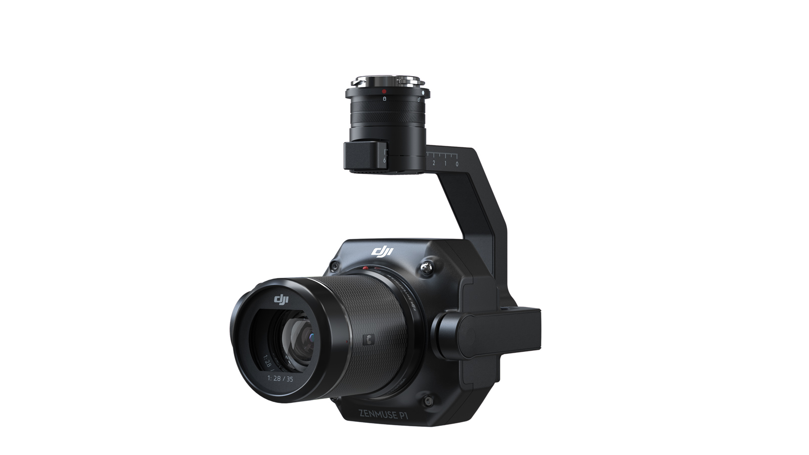


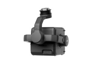
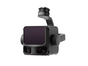
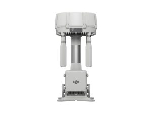
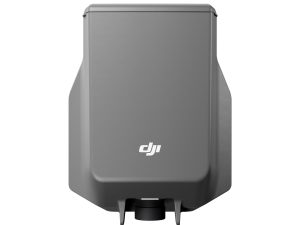
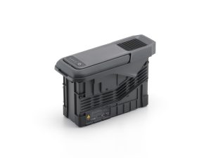
DJI Zenmuse P1 Camera Body
£5,280.00
- Compatible with M400, M350 & M300 RTK
- 45 MP full-frame sensor
- Global mechanical shutter
- Includes 35mm lens
- 1-year AA Care Plan
DJI Zenmuse P1 — Full Frame Photogrammetry Camera
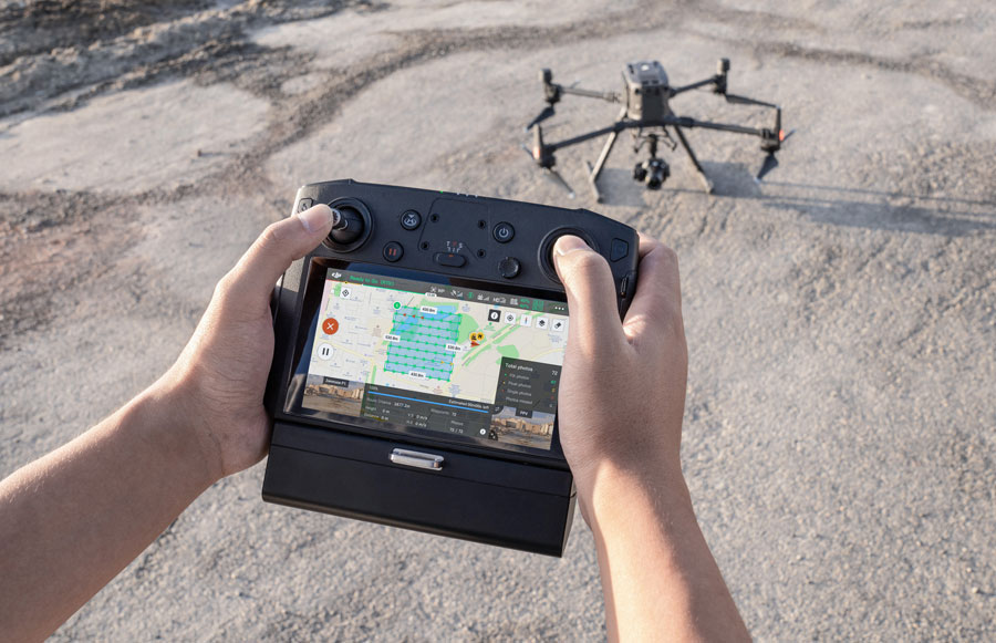
The DJI Zenmuse P1 integrates a 45-megapixel full frame sensor, global mechanical shutter, and a fixed focus lens system on a 3-axis stabilised gimbal — engineered for rapid, highly accurate aerial surveying, mapping, and inspection missions. Authorised and supported by Drone Sales UK.
Global Mechanical Shutter
3 cm Horizontal Accuracy (No GCPs)
3 km² Single-Flight Coverage
3-Axis Stabilised Gimbal
TimeSync 2.0 Precision
The Enterprise Mapping Benchmark
High precision geospatial workflows demand uncompromised data fidelity and exceptional operational speed. By combining a large format sensor with an optimised mechanical shutter, the Zenmuse P1 eliminates rolling shutter distortion entirely, allowing aircraft to map at peak operational flight velocities without degrading data accuracy.
- Achieves remarkable horizontal accuracy down to 3 cm and vertical accuracy of 5 cm without traditional ground control networks
- Covers massive expanses up to 3 km² during a single data flight, drastically reducing time on site
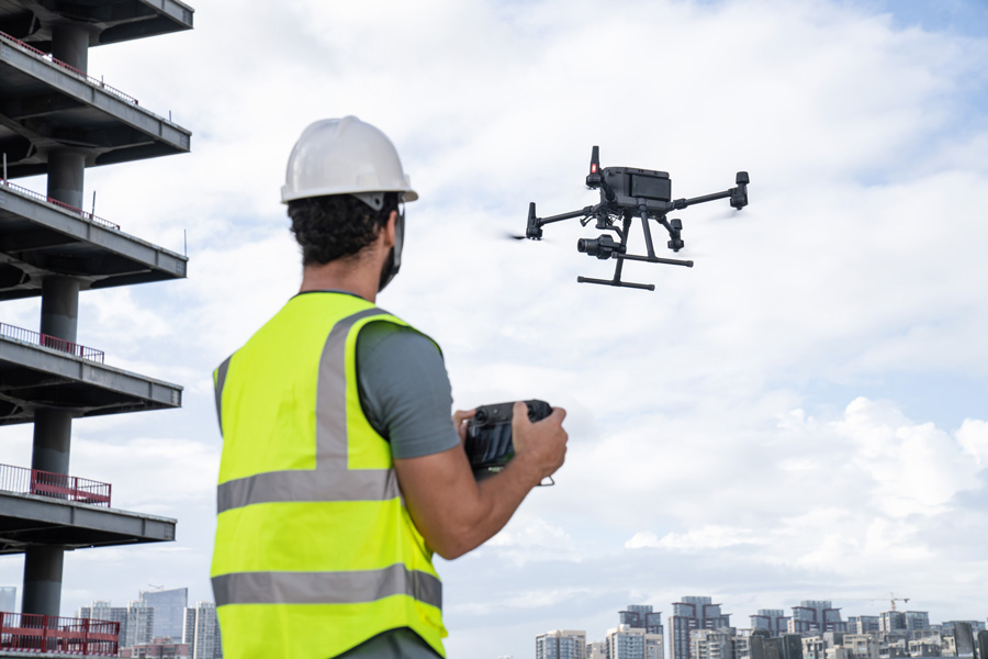
- Seamlessly pairs with flagship DJI Matrice commercial aircraft for survey grade RTK integration
Survey-Grade Efficiency
Built to satisfy rigid commercial surveying specifications, the P1 pairs its high resolution architecture with advanced software synchronisation.
- Real Time Integration: Coordinates with TimeSync 2.0 to link position data down to the microsecond level.
- Reduced Site Overhead: High natural accuracy removes the dependency on labour intensive GCP arrays.
- Consistent GSD: Fast 0.7-second shutter interval guarantees uniform pixel coverage across wide fields.
Smart Oblique Capture & Large Scale Coverage
Maximise output during complex urban planning or infrastructure tasks. The motorised gimbal swings dynamically during flight to secure vital multi angle perspectives automatically.
- Intelligent Rotation: Captures look-down nadir along with multi-directional oblique textures in a single sweep.
- 3D Edge Precision: Generates crisp vertical façade modeling for detailed structural twins.
- Optimized Flight paths: Drops image repetition on boundary edges, increasing clean data throughput by up to 20%.
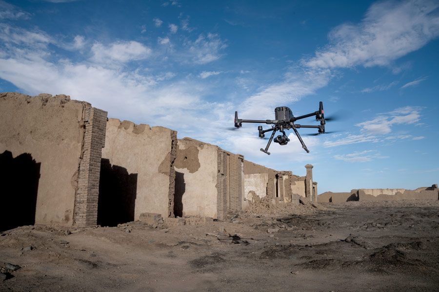
Industrial Versatility Across Environments
From environmental tracking to extreme industrial locations, the P1 maps unpredictable topography without losing focal stability.
- Aggregated Material Tracking: Simplifies continuous volumetric analysis in open cast quarries and mines.
- Dense Canopy Penetration: Creates clean high-altitude orthomosaics for environmental management.
- Rugged Housing Architecture: Built to endure variable field environments for predictable year round operation.
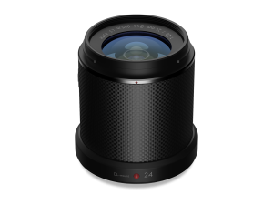
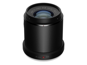
Tailored Optics: Which Lens Should I Add?
The Zenmuse P1 utilises interchangeable DJI DL-series lenses to match your specific dataset goals. Select the optical profile that balances field-of-view speed against granular structure details.
Pro Tip: Always balance payload altitude and image overlap margins against your target Ground Sampling Distance (GSD). Use RTK network data links alongside built-in TimeSync tracking to verify centimetre accurate data collection on every pass.
How the Zenmuse P1 Compares to Specialised Platforms
Choosing the optimal image sensor is determined by matching accuracy targets to asset size. The Zenmuse P1 is distinguished by its massive full-frame sensor and mechanical shutter, outclassing generic multi-rotor configurations for pure surveying performance.
| Feature / Spec | Zenmuse P1 (Full Frame) | Agras T25P (Mapping FPV) | Standard Small Drone (1 inch) |
|---|---|---|---|
| Sensor Architecture | 45 MP Full Frame (35mm) | Adjustable HD Mapping FPV | 20 MP 1 inch CMOS |
| Shutter Type | Mechanical Global (No Distortion) | Electronic Shutter Blend | Electronic / Mechanical Mix |
| Lenses Support | Interchangeable DL (24/35/50 mm) | Fixed Wide Focal Layout | Fixed Native Lens Group |
| Primary Focus | Survey Grade Engineering: High Accuracy. | Field scouting and crop swath routing. | General asset visual inspection checks. |
DJI Zenmuse P1 — Frequently Asked Questions
What is the DJI Zenmuse P1?›
The DJI Zenmuse P1 is a full-frame photogrammetry camera designed for aerial surveying and mapping. It features a 45 MP sensor, mechanical shutter, and interchangeable lenses, delivering centimetre-level accuracy when paired with RTK/PPK workflows.
Which drones is the P1 compatible with?›
The P1 is compatible with the DJI Matrice 300 RTK and Matrice 350 RTK, using the DJI SkyPort V2.0 interface. Missions are planned and flown using DJI Pilot 2.
What are the key specifications (sensor, resolution, shutter)?›
The P1 has a 45 MP full-frame sensor (35.9 × 24 mm, 8192 × 5460 pixels), 4.4 μm pixel size, and a global mechanical shutter up to 1/2000 s, enabling crisp capture during fast flight.
What lenses are supported and what focal lengths can I use?›
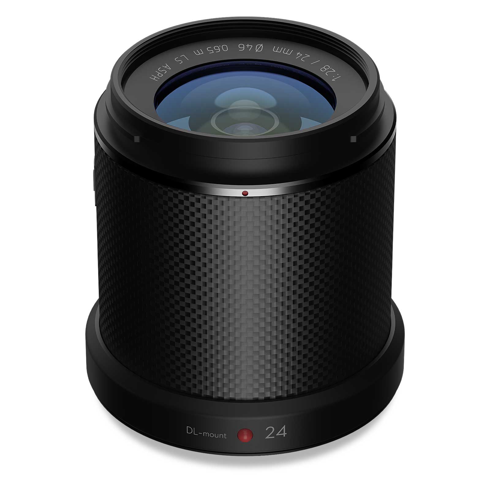
The P1 supports DJI DL series lenses: 24 mm, 35 mm and 50 mm fixed-focus. This allows balancing coverage area with required ground resolution.
How accurate are surveys captured with the P1?›
With RTK or PPK enabled and correct workflow, the P1 can achieve ~3 cm horizontal and ~5 cm vertical accuracy without ground control points, depending on conditions.
How much area can I cover per flight?›
Under typical conditions (~150 m AGL, 75% overlap), the P1 can cover up to ~3 km² in a single flight, depending on battery, terrain and wind.
What mission types are supported?›
The P1 supports 2D orthomosaics, 3D oblique models, corridor mapping, façade and vertical surveys, and detailed reconstruction workflows.
What are the size, weight and operating limits?›
Approx. size is 198 × 166 × 129 mm; weight ~800 g (lens excluded). Operating range: –20 °C to +50 °C; IP4X dust resistance in lab conditions.
Do I need GCPs to get accurate results?›
The P1 can achieve high accuracy without GCPs when RTK or PPK is used properly. However, check points are advised for verification and compliance.
What software can I use to process the data?›
DJI Terra supports full P1 workflows including orthos, point clouds and 3D models. You can also use third-party tools like Pix4D, Agisoft or LP360 as needed.
What are typical UK use cases?›
Common jobs include topographic mapping, site surveys, construction progress, urban planning, forestry, asset inspection and flood modelling.
What accessories or prep is recommended?›
Use quality DL lenses, UHS-I SD cards, RTK or base station, and check calibration. GCPs or checkpoints improve QA. Keep firmware up to date and store dry.
DJI Zenmuse P1 — Full-Frame Photogrammetry Payload Specifications
The benchmark for high-efficiency, high-accuracy aerial photogrammetry. Integrating a massive 45 megapixel full-frame sensor with custom low-distortion DL lenses on a highly stabilized 3-axis gimbal, the Zenmuse P1 is engineered to deliver millimeter-level data logging accuracy for complex mapping, surveying, and 3D reconstruction missions.
3 cm Horiz. / 5 cm Vert. Accuracy
0.7 s Minimum Photo Interval
Mechanical Leaf Shutter Core
Interchangeable DL Optics Ecosystem
IP4X Solid-Particle Protection
General Architecture & Aircraft Compatibility
- Physical Footprint: Rugged, specialized surveying housing measuring 198×166×129 mm. Total net payload weight tracks at approximately 800 grams.
- Power Requirements: Highly optimized operational power loop drawing a stable typical consumption of 20W.
- Ingress Protection: Rated at IP4X protection levels to safeguard delicate internal optical mechanisms from solid foreign objects and fine debris infiltration.
- Supported Aircraft Platforms: Adapts natively via a detachable DJI SKYPORT interface to the Matrice 300 RTK, Matrice 350 RTK, and Matrice 400 flight platforms.
- Thermal Operating Thresholds: Sustains absolute measurement precision across a wide climate window spanning -20° to 50° C (-4° to 122° F), with safe storage boundaries rated from -20° to 60° C.
Full-Frame Sensor & Optical Interchangeability
- Sensor Proportions: Large full-frame mapping sensor measuring 35.9×24 mm for still capture profiles (max video recording area crops dynamically to 34×19 mm).
- Image Resolution: Delivers 45 Megapixels of effective resolution throwing native 3:2 aspect ratio stills matching a crisp 8192×5460 pixel grid.
- Pixel Architecture: 4.4 μm pixel pitch ensures incredible dynamic range, superior signal-to-noise indexing, and immaculate performance during low-light survey windows.
- Interchangeable Prime Optics: Integrates with DJI’s custom DL lens ecosystem, featuring specialized leaf shutters, dedicated balancing rings, filters, and custom hoods:
- DJI DL 24mm F2.8 LS ASPH: Wide configuration providing an 84° diagonal field of view (DFOV).
- DJI DL 35mm F2.8 LS ASPH: Standard photogrammetry profile delivering a 63.5° DFOV.
- DJI DL 50mm F2.8 LS ASPH: High-altitude surveying layout throwing a tighter 46.8° DFOV.
- Exposure Control: Operational aperture values span f/2.8 to f/16. Sensor ISO scales cleanly from 100 to 25,600 across both standalone photo and video capturing arrays.
Surveying Speeds, Precision Accuracy, & Capture Dynamics
- Absolute Target Accuracy: Achieves horizontal positioning tolerances down to 3 cm and vertical coordinate profiling within a 5 cm window without the strict requirement of Ground Control Points (GCPs).
- Rapid-Fire Shooting Buffer: Squeezes down the minimum photo interval to a blistering 0.7 seconds, unlocking dense data capture rates at rapid aircraft transit velocities.
- Mechanical Shutter Core: Heavy-duty mechanical leaf shutter architecture completely wipes out rolling-shutter pixel skewing at rapid speeds. Shutter speed spans 1 s down to 1/2000 s (note: mechanical lock limits apply to apertures no larger than f/5.6).
- Electronic Shutter Capabilities: High-speed backup electronic sensor shutter tracks from 1 s down to an ultra-fast 1/8000 s.
- Video Capture Configurations: Records smooth broadcast-grade MP4 or MOV containers at 60fps frame rates. Supports 1920×1080 Full HD across all configurations, and high-bitrate 3840×2160 4K Ultra HD (4K video restricted exclusively to the 35mm lens).
3-Axis Gimbal Control & Data Logging Protocols
- Gimbal Stabilization: Enterprise-tier 3-axis (tilt, roll, pan) active mechanical tracking loop. Restrains angular vibration deviations to a tight ±0.01° layer. Operating modes feature Follow, Free, and rapid automated Re-center scripts.
- Mechanical Axis Boundaries: Structural frame layout permits extreme movement limits including a Tilt sweep of -130° to +40°, a Roll threshold of -55° to +55°, and Pan parameters stretching up to ±320°.
- Unified Storage Pipelines: Directly groups mission-critical datasets together into single folder hierarchies, linking high-res photos, raw GNSS observation logs, and specialized precision image log files (TimeSync data).
- Memory Demands: Requires high-speed exFAT formatted SD storage media rated at UHS-I or above, with structural capacity limits supporting up to a 512 GB maximum.
* Target absolute accuracy profiles are calculated using a standardized Mapping Mission format at a Ground Sample Distance (GSD) of 3 cm while sustaining a continuous flight speed of 15 m/s, backed by a 75% front overlap rate and a 55% side overlap rate. Ensure the camera lens is perfectly clear of dust or condensation before initializing automated orthomosaic surveying routines.
Downloads
Software & Utilities

Windows Version
Windows Version
Firmware Archive
💾
Firmware Update
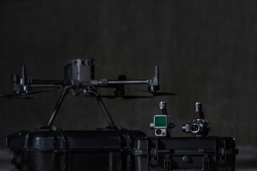
Related Products
-
DJI BS100 Intelligent Battery Station
£1,150.00 Buy Now -
DJI Zenmuse L3
£13,150.00 Buy Now -


DJI M400 Surveying & Mapping Pro
£33,407.00 Buy Now -


DJI M400 Inspection & Infrastructure
£21,210.00 Buy Now -
DJI O4 Ground Station
£1,880.00 Buy Now -
Manifold 3
£1,160.00 Buy Now -
DJI AP100 Parachute
£1,010.00 Buy Now -
Zenmuse X7 DJI DL 24mm
£1,299.00 Buy Now -
Zenmuse X7 DJI DL 50mm
£1,199.00 Buy Now -
TB100 Flight Battery
£1,320.00 Buy Now