Skip to content

01305 303101

hello@dronesales.co.uk

Row midpoint Shape Decorative svg added to bottom
Header-White-Stroke-Logo

Drone Store & Service Centre

vaspba-group-web-logo

7
6
4
3
1
2
  • Products
    • Beginner
      • DJI Mini 5
      • DJI Mini 4
      • DJI Lito
      • DJI Neo 2
      • DJI Flip
    • Professional
      • DJI Mavic 4
      • DJI Air 3S
      • DJI Inspire 3
    • Enterprise
      • DJI Dock
      • DJI FlyCart
      • DJI Matrice 400
      • DJI Matrice 4
      • Software
    • Agricultural
      • DJI Agras T100
      • DJI Agras T50
      • DJI Agras T25
      • DJI Mavic 3M
    • FPV
      • DJI Avata 360
      • DJI Avata 2
    • Waterproof Drones
      • Splashdrone 4+
      • Fisherman (FD1+)
      • Fisherman Max (FD2)
      • Fisherman 3 (FD3)
    • Accessories
      • DJI Goggles 3
        • Aero Ping
      • Waterproof Tablet
  • Blog
  • Aeroguard
  • Contact
  • £0.00
Trustpilot

DJI Terra — Fast, Accurate Drone Mapping & 3D Reconstruction

DJI Terra turns drone data into high-quality maps and models for agriculture, surveying, and asset inspection.
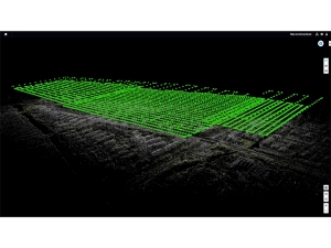
Process 2D/3D photogrammetry, DJI LiDAR datasets, and 3D Gaussian Splatting (3DGS) — all in one toolkit.

  • Plan: Waypoint, area & corridor missions; terrain-follow & RTK/PPK workflows.
  • Process: Orthomosaics, DEMs, point clouds, textured meshes, LiDAR and 3DGS.
  • Apply: NDVI/NDRE indices, prescription maps, measurements & reports.
  • Editions: Agriculture, Pro, Electricity & Cluster (online/offline licences).


Explore Features


Specifications


Read FAQs

Home / Agricultural / DJI Terra

Showing the single result

  • DJI Terra

    DJI Terra

    £1,600.00 – £11,150.00Price range: £1,600.00 through £11,150.00
    Select options This product has multiple variants. The options may be chosen on the product page
drone-sales-dji-agricultural-Logo-Landscape

Innovation Above All.
Precision. Sustainability. Progress.

DJI Terra — Fast Mapping, 3D Models & Precision Analysis

DJI Terra transforms UAV imagery into high-quality maps, 2D orthos and advanced 3D models using photogrammetry or the latest Gaussian Splatting techniques. Perfect for UK farms, land managers, agronomists and precision-ag workflows.

2D Orthomosaics NDVI / Index Maps 3D Models Gaussian Splatting Photogrammetry RTK / PPK Supported
DJI Terra mapping software overview

Precision Mapping & Survey Output

Create ultra-sharp orthomosaics, NDVI layers, contours and elevation models using drone flights. Perfect for agronomy, drainage planning, environmental mapping and field insights.

  • Accurate DSM/DTM generation
  • Index maps: NDVI, NDRE, VARI & custom bands
  • RTK/PPK for survey-grade accuracy
  • Compatible with agricultural workflows and GIS tools

Field Monitoring & Data-Driven Decisions

Terra is ideal for crop assessments, land management and environmental reporting — giving you a clear view of plant health, boundaries and seasonal change.

  • Compare fields across seasons
  • Create zoning maps and prescription areas
  • Spot issues early: lodging, water stress, disease patches
  • Export to GIS, agronomy apps or farm management systems

Gaussian Splatting Model

Photogrammetric 3D Model

A single processing workflow showcasing both Gaussian Splatting (left) and Photogrammetry (right), giving you visual speed and measurement-grade accuracy in one output.

Why DJI Terra for UK Agriculture?

Fast Data Processing Multi-Model Reconstruction Precision Mapping Tools RTK-Aligned Outputs Measurement-Ready Models Ideal for Surveying & Planning

Want DJI Terra for your farm or business? Drone Sales UK can set up your workflow, licences and training.

Enquire Now

DJI Terra — Frequently Asked Questions

What does DJI Terra actually do?

Terra plans flight missions and converts drone imagery & LiDAR into orthos, DEMs, point clouds and 3D models.

Which Terra edition should I choose?

Agriculture, Pro, Electricity or Cluster — choose based on workflow requirements.

Does Terra work offline?

Yes — offline licences work on isolated, air-gapped networks.

Is there a Mac version?

No — Terra is Windows-only.

What PC spec is recommended?

64GB RAM, RTX GPU, NVMe SSD for large datasets.

DJI Terra — Key Specifications

Enterprise-grade mapping and reconstruction software for aerial RGB, multispectral and LiDAR workflows.

2D & 3D Mapping LiDAR Point Clouds Cluster Processing Windows 10/11 CUDA Acceleration
System & Software Requirements
  • Operating System: Windows 10/11 (64-bit)
  • CPU: Multi-core processor (Intel i7 or equivalent recommended)
  • RAM: Minimum 16 GB; 32–64 GB recommended for large datasets
  • GPU: NVIDIA GPU with CUDA support (RTX series recommended)
  • Storage: NVMe SSD strongly recommended
  • Workflows Supported: 2D orthos, DSM/DTM, 3D meshes, point clouds, LiDAR processing, 3DGS
  • Licensing: Agriculture, Pro, Electricity & Cluster editions available

*Performance depends on dataset size, hardware specification, reconstruction resolution and workflow type.

DJI Terra — Video Overview

Row concave Shape Decorative svg added to top
Header-White-Stroke-Logo
Please enter a valid email address.
Subscribe

Thanks for subscribing!

Something went wrong. Please check your entries and try again.

Latest News

£50 Million Drone Investment: What It Means for UK Agriculture and Commercial Drone Operators

May 6, 2026

Top Tips For Flying A Drone Over Water

April 23, 2026

DJI Repair Centre

April 17, 2026

The Avata 360: Why “Traditional” FPV Just Became Obsolete

April 15, 2026

Explore

  • Products
    • Beginner
      • DJI Mini 5
      • DJI Mini 4
      • DJI Lito
      • DJI Neo 2
      • DJI Flip
    • Professional
      • DJI Mavic 4
      • DJI Air 3S
      • DJI Inspire 3
    • Enterprise
      • DJI Dock
      • DJI FlyCart
      • DJI Matrice 400
      • DJI Matrice 4
      • Software
    • Agricultural
      • DJI Agras T100
      • DJI Agras T50
      • DJI Agras T25
      • DJI Mavic 3M
    • FPV
      • DJI Avata 360
      • DJI Avata 2
    • Waterproof Drones
      • Splashdrone 4+
      • Fisherman (FD1+)
      • Fisherman Max (FD2)
      • Fisherman 3 (FD3)
    • Accessories
      • DJI Goggles 3
        • Aero Ping
      • Waterproof Tablet
  • Blog
  • Aeroguard
  • Contact

Brands

  • Swellpro
  • DJI Consumer
  • DJI Enterprise
  • DJI Agricultural

Account

  • My account
  • Cart
  • Checkout
  • Blog
  • Privacy Policy
  • Refund and Returns Policy
  • Cookie Policy
  • £0.00

Get in touch

Drone Sales UK
Chesil House
Dorset Innovation Park
Wool
DT2 8ZB

hello@dronesales.co.uk

01305 303101

Join 20k Other Like Minded Drone Enthusiasts

Drone Sales UK Send us a message
Hi, please leave your details and message. You can also attach an image or PDF if it helps.