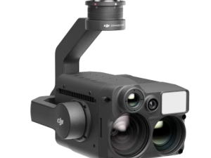
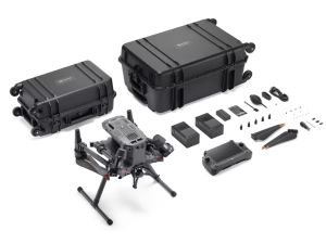
DJI Zenmuse L1
£11,600.00
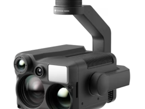
- DJI’s 1st LiDAR Camera
- Use with DJI M300 Matrice
- 240,000 effective points
- Use DJI Terra for post-processing
Out of stock
DJI Zenmuse L1
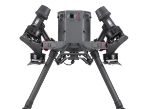
DJI is responsible for developing the Zenmuse L1 camera. The L1 from DJI is the first lidar payload the firm has ever created. A Livox Lidar Module, an IMU with very high precision, and a camera with a 1-inch CMOS are all mounted on a gimbal that is stabilised on three axes. As a direct consequence of this, post-processing will run more smoothly. The Zenmuse L1 payload attaches to the Matrice 300 RTK directly. This provides you with real-time 3D data throughout the day, allowing you to capture the details quickly.
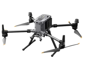
When used with stunning Matrice 300 RTK and DJI Terra, the DJI Zenmuse L1 forms a complete solution that gives you real-time 3D data throughout the day, efficiently capturing the details of complex structures and delivering highly accurate reconstructed models.
Cutting-Edge LiDAR Technology for Precision Mapping
The DJI Zenmuse L1 is revolutionising the way aerial surveys and mapping are conducted. Featuring an integrated Livox LiDAR module, this state-of-the-art payload captures highly accurate 3D point cloud data in real time, providing survey-grade results with unparalleled efficiency. The Zenmuse L1 also incorporates a high-precision inertial measurement unit (IMU) that enhances positional accuracy, ensuring data reliability even in complex environments. This cutting-edge technology enables professionals to gather precise data for tasks like topographical mapping, forestry analysis, and infrastructure inspections. The LiDAR module is capable of collecting 240,000 points per second, with a detection range of up to 450 metres, making it ideal for mapping large areas with ease. Whether you’re surveying dense vegetation or urban landscapes, the Zenmuse L1’s ability to penetrate canopies and capture accurate data sets it apart. With its lightweight design and seamless integration with DJI’s Matrice 300 RTK drone, this payload transforms the efficiency of fieldwork. Professionals with these enterprise drones can now complete extensive surveys in a fraction of the time compared to traditional methods, reducing costs and improving productivity. For industries reliant on detailed geospatial data, the Zenmuse L1 is a game-changer, combining advanced LiDAR capabilities with DJI’s trusted innovation.
Advanced Imaging with the Integrated 1-Inch CMOS Camera
In addition to its powerful LiDAR module, the DJI Zenmuse L1 features an integrated 1-inch CMOS camera with a 20-megapixel sensor. This high-resolution camera captures stunning RGB imagery that complements the LiDAR data, enabling professionals to create photorealistic models and detailed orthomosaics. The camera’s large aperture and high dynamic range ensure exceptional performance even in low-light conditions, making it suitable for diverse environments and challenging lighting scenarios. The Zenmuse L1’s imaging capabilities are particularly valuable for applications requiring both spatial and visual data. For instance, construction professionals can use the combined LiDAR and camera data to monitor site progress, detect structural changes, and create precise 3D renderings for planning and analysis. Environmental researchers benefit from the ability to visualise vegetation patterns and land changes with high accuracy, while surveyors can achieve detailed mapping results that meet the highest industry standards. Seamless integration with DJI Terra software further enhances the Zenmuse L1’s imaging potential. By combining LiDAR point cloud data with RGB imagery, users can create comprehensive 3D models and analyse data efficiently. This all-in-one solution simplifies workflows, reduces processing time, and delivers actionable insights, making the Zenmuse L1 an indispensable tool for professional aerial operations.
Seamless Integration and Efficiency with DJI Ecosystem
The DJI Zenmuse L1 is designed to work seamlessly with the DJI Matrice 300 RTK, creating a powerful aerial surveying and mapping platform. This integration allows professionals to leverage the drone’s advanced flight stability, RTK positioning accuracy, and extended flight times to maximise data collection efficiency. Combined with DJI Terra, the Zenmuse L1 streamlines the workflow from data acquisition to processing, making it an essential tool for industries reliant on geospatial data. The ease of deployment is one of the Zenmuse L1’s standout features. With its plug-and-play design, operators can quickly attach the payload to the Matrice 300 RTK and begin collecting data with minimal setup time. The system also supports real-time point cloud rendering, enabling professionals to make decisions on-site and reduce the need for repeat flights. The Zenmuse L1’s durability further enhances its value for challenging environments. With an IP54 rating, it is resistant to dust and water, ensuring reliable performance in a variety of conditions, from construction sites to dense forests. By integrating seamlessly with DJI’s robust ecosystem, the Zenmuse L1 not only improves data accuracy but also significantly boosts operational efficiency, making it a transformative tool for modern aerial surveying.