 Skip to content


Agricultural drones have rapidly transformed the landscape of modern farming. From crop monitoring and spraying to field mapping and data analysis, drones are becoming an essential tool for farmers across the UK. One of the most common questions we receive at Drone Sales UK is: how many acres can an agricultural drone cover? The answer, as you might expect, depends on several factors, including the drone model, payload, battery life, and the specific agricultural task being performed.
In this blog, we’ll explore the variables that influence drone coverage, break down performance metrics from popular drone models, and provide practical insights to help UK farmers and landowners make an informed choice. Whether you’re managing a smallholding in Lincolnshire or overseeing vast fields in Yorkshire, understanding your drone’s capabilities is vital to maximising both efficiency and ROI.
Understanding the Basics of Agricultural Drone Coverage
Before diving into acreage numbers, it’s helpful to understand what coverage means in the context of agricultural drones. Coverage refers to the amount of land a drone can service within a single flight or over a given time period, such as per hour or per day. This can vary depending on whether the drone is being used for spraying, seeding, surveying, or imaging.
Different drones are optimised for different tasks. A drone built for crop spraying will have different specs compared to one designed for aerial imagery. Coverage is not just a factor of flight time and speed, but also of how the drone applies its payload and how effectively it navigates the terrain.
For farmers here in the UK, where weather, field shape, and environmental regulations come into play, real-world drone performance may differ from manufacturer claims. That’s why it’s crucial to assess drone specifications in a practical, boots-on-the-ground context.
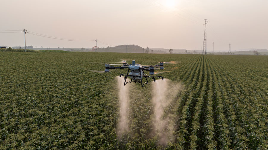
Coverage Capabilities of Spraying Drones
One of the most common applications of agricultural drones is precision spraying—be it pesticides, herbicides, or liquid fertilisers. Spraying drones come with tanks that typically range from 10 to 30 litres, depending on the make and model. The coverage of these drones hinges on both the tank capacity and spray width, as well as flight speed and battery endurance.
A mid-range drone such as the DJI Agras T30, which is popular among UK growers, can spray approximately 16 to 20 acres per hour under optimal conditions. On smaller farms, this might mean completing a full spraying cycle in one or two flights. However, on larger arable farms in the East Midlands or Cambridgeshire, this may require coordinated fleet operations or multiple battery swaps.
It’s important to remember that the rate of application also affects coverage. For example, if you’re applying at a higher rate (say, 20 litres per hectare), you’ll cover less acreage per flight than if you were spraying at 10 litres per hectare. This is particularly relevant in the UK, where legal limits and crop-specific requirements must be followed closely.
Mapping and Surveying Drones Cover More Ground
When it comes to field mapping and crop health monitoring, drones can typically cover much larger areas than spraying drones. This is because they’re not carrying heavy liquid payloads, allowing for longer flight times and broader sensor coverage.
A fixed-wing drone, for instance, can map hundreds of acres in a single flight. Models like the senseFly eBee or DJI Mavic 3 Multispectral are designed for high-efficiency scanning and can cover up to 500 acres per day, depending on resolution settings. Fixed-wing drones fly faster and longer than multi-rotor models, making them ideal for large-scale terrain assessments, particularly in areas like the Scottish Borders or Norfolk where expansive plots are common.
Multi-rotor drones still play a key role in mapping for smaller farms or fields with irregular boundaries. They offer more control at lower altitudes and are generally easier to deploy. A multi-rotor mapping drone might cover 80 to 120 acres in a few flights, which is more than sufficient for many UK farms.
Factors That Influence How Much a Drone Can Cover
Coverage estimates are only useful if they take into account real-world variables. In the UK, drone performance can be significantly influenced by terrain, weather conditions, crop type, and even local legislation.
Battery life is a primary factor. Most agricultural drones fly for around 20 to 30 minutes per battery cycle. Cold weather, common in many parts of the UK, can reduce battery efficiency, cutting down on the drone’s operational range. Wind and rain can also ground a drone altogether, which is why reliable forecasting and flexible planning are key to effective drone deployment.
Field size and shape also matter. Large, rectangular fields are easier for drones to cover efficiently, with fewer turns and less overlap. In contrast, small or oddly shaped plots, typical of farms in the South West or Wales, can lead to inefficiencies and reduce effective coverage.
The skill of the operator should not be underestimated either. Experienced pilots can plan optimal flight paths, minimise idle time, and respond quickly to mid-flight challenges. While many drones offer autonomous flight modes, having a qualified drone operator—particularly one familiar with UK agriculture—can make a significant difference in actual coverage per flight.
How UK Regulations Affect Agricultural Drone Use
In the UK, drone usage for agricultural purposes is governed by the Civil Aviation Authority (CAA). For commercial operations, including crop spraying and mapping, drone pilots must hold a GVC (General Visual Line of Sight Certificate) and operate within the confines of legal flight paths and height restrictions.
These regulations can influence how many acres you can cover, especially if you’re working near populated areas or controlled airspace. There are also specific requirements for spraying drones, such as ensuring safe distances from water sources, people, and protected habitats. It’s important to plan your flights with these rules in mind to avoid penalties or interruptions.
That said, the regulatory landscape is evolving. The UK government has shown increasing support for agri-tech innovation, including drones. New permissions and expanded BVLOS (Beyond Visual Line of Sight) trials are being explored, which could eventually allow drones to cover even larger areas with fewer restrictions.

Cost vs Coverage: Finding the Right Drone for Your Operation
It’s easy to get caught up in specs and marketing claims, but for most UK farmers, the right drone is one that balances cost with capability. A larger drone may cover more acres per hour but comes with a higher upfront cost, as well as additional maintenance and training requirements.
If you’re a small to medium-sized farmer in regions like Kent or Shropshire, a drone with a 10-litre tank and 30-minute flight time may be more than enough to meet your needs. For larger estates or contract spraying services, investing in a 30-litre spraying drone or a fleet of mapping drones could offer a better return in terms of time saved and operational scale.
We often advise clients to think in terms of workflow rather than just acreage. How long does it take to complete a task? How many battery swaps are needed? How easy is it to transport and set up the drone in the field? These practical questions help determine the real-world acreage you can cover per day—not just what’s printed on the spec sheet.
Drone Fleet Management for Larger Acreage
For operations that involve covering hundreds or even thousands of acres regularly, a single drone may not be enough. This is where drone fleet management comes in. Deploying multiple drones simultaneously—each operated by a qualified pilot—can dramatically increase your coverage area.
We’re seeing more agricultural contractors in the UK adopt this approach. By using two or three spraying drones in tandem, teams can cover over 100 acres in a day with minimal downtime. Fleet management software allows for coordination, flight logging, and battery monitoring in real time, streamlining the process and reducing operational headaches.
This model also opens up opportunities for drone-as-a-service businesses. With the right licensing and equipment, operators can offer spraying, seeding, or mapping services to farms without requiring each client to invest in their own drone. It’s a growing market, and one we at Drone Sales UK are keeping a close eye on.
The Future of Agricultural Drone Coverage in the UK
Technology is advancing rapidly, and drone coverage capabilities will only improve. Lighter batteries, AI-assisted navigation, and BVLOS permissions are all poised to expand the range and efficiency of drone operations in agriculture.
Drones are also being integrated with farm management software, IoT sensors, and satellite data to provide a full-circle view of crop health and yield potential. This interconnected ecosystem allows farmers to act on data quickly and with precision—reducing waste, improving yield, and increasing sustainability.
We expect to see more autonomous drone fleets operating with minimal human input, covering hundreds of acres per day with high precision. For the UK’s agriculture sector, this means lower labour costs, reduced chemical use, and more resilient food production systems.
Final Thoughts: What Coverage Should You Expect?
So, how many acres can an agricultural drone cover? If you’re using a spraying drone like the DJI Agras T40 or T30, expect to cover between 15 and 25 acres per hour, depending on conditions and spray rates. For mapping drones, the coverage is much higher—anywhere from 100 to 500 acres in a day is possible with the right equipment and flight planning.
But numbers only tell part of the story. Terrain, weather, regulations, drone type, and operator experience all influence how many acres you can realistically cover in a day. That’s why we always recommend speaking with a knowledgeable supplier—like us at Drone Sales UK—who understands the unique needs of British agriculture.
If you’re unsure which drone is right for your farm, or if you want to explore options for fleet operations or training, get in touch with us. We offer hands-on demos, CAA-approved pilot training, and expert guidance to help you maximise your drone investment.
In the ever-evolving world of agri-tech, drone coverage is not just about how far you can fly—it’s about how effectively you can manage your land. With the right drone and strategy, you can make every acre count.