 Skip to content


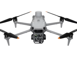
DJI Matrice 4E
£3,940.00
- Up to ~59-minute flight time
- Wide, zoom & laser sensor flexibility
- RTK precision for accurate mapping
- O4 Enterprise transmission system
- Rugged, weather-resistant build
DJI Matrice 4E — Precision Mapping & Inspection for UK Enterprise Teams
The DJI Matrice 4E is the visible-spectrum specialist in the Matrice 4 Series,
purpose-built for high-accuracy mapping, surveying, inspection and engineering workflows.
Featuring a 20 MP mechanical-shutter camera, dual 48 MP telephoto sensors,
a 3000 m laser rangefinder and O4 Enterprise transmission,
the Matrice 4E delivers exceptional data quality in demanding UK conditions.
48 MP Medium Tele
48 MP Tele Camera
3000 m Laser Rangefinder
Up to ~49 min Flight
O4 Enterprise Transmission
RTK Optional

20 MP Mechanical-Shutter Camera for Mapping Accuracy
The Matrice 4E’s primary wide camera is engineered for distortion-free mapping and photogrammetry:
- 20 MP 4/3″ CMOS with mechanical shutter.
- Eliminates rolling-shutter distortion for survey accuracy.
- Fast capture improves mission productivity.
- Ideal for construction, surveying and engineering workflows.
48 MP Medium Tele + 48 MP Tele for High-Detail Inspections
Two high-resolution telephoto cameras support safe and detailed standoff inspections:
- 48 MP Medium Tele — mid-range clarity for asset checks.
- 48 MP Tele — detailed capture of distant structures.
- Perfect for utilities, rail, industrial and infrastructure inspections.
- Stabilised HD feed via O4 Enterprise Transmission.
3–3000 m Laser Rangefinder for Precision Measurement
The LRF provides object distance, size and elevation data instantly — critical for documentation and planning.
- 3–3000 m measurement range.
- Instant target metadata for engineering workflows.
- Enhances repeatability in surveys and inspections.
- Ideal for highway, rail, telecoms and energy sectors.
Extended Flight Time & Enterprise Reliability
The Matrice 4E offers long endurance and rugged reliability for UK field teams:
- Up to ~49 minutes maximum flight time.
- IP-rated weather protection for rain and coastal environments.
- O4 Enterprise connectivity for stable long-range control.
- Hot-swappable batteries for uninterrupted missions.
Example UK Use Cases
Surveying & Mapping
Accurate orthomosaics, land surveys and digital twins.
Inspection & Asset Management
Utilities, rail, telecoms, structures and industrial sites.
Construction & Engineering
Progress tracking, BIM updates and terrain analysis.
Related Products
-

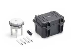
D-RTK 3 Multifunctional Station
£1,369.00 Buy Now -
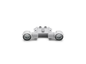
DJI AL1 Spotlight
£259.00 Buy Now -

DJI AS1 Speaker
£199.00 Buy Now -


Matrice 4D Standalone Combo
£5,985.00 Buy Now -

Matrice 4TD Standalone Combo
£7,725.00 Buy Now -


DJI Neo Fly More Combo
£299.00 Read more -


DJI Neo (Drone Only)
£169.00 Read more -


DJI Neo Motion Fly More Combo
£449.00 Read more -

DJI Matrice 4T
£5,910.00 Buy Now -

DJI Matrice 4 Series Battery
£159.00 Buy Now