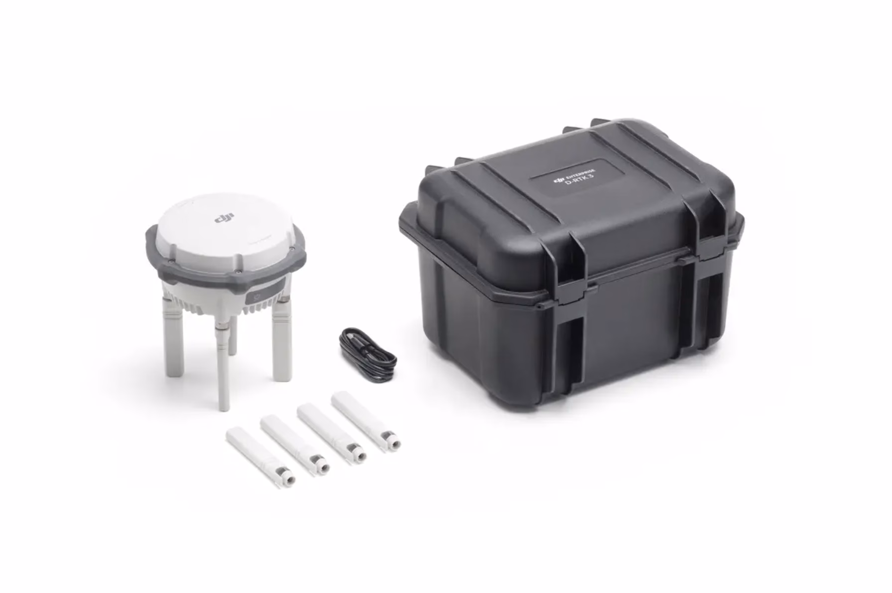

D-RTK 3 Multifunctional Station
£1,369.00
- Centimetre-level RTK positioning accuracy
- Supports Base, Rover & Relay modes
- Compatible with DJI Matrice & Agras drones
- IP67 weather-sealed, field-ready design
- Multi-hour battery with USB-C PD charging
DJI D-RTK 3 Multifunctional Station — Centimetre-Level Accuracy for UK Enterprise Teams
The DJI D-RTK 3 Multifunctional Station is a next-generation GNSS base station designed to deliver
centimetre-level positioning accuracy for complex surveys, mapping missions, automated flights,
and high-precision inspection work across the UK.
Built for the Matrice 4 Series and other DJI enterprise platforms, the D-RTK 3 supports
multi-constellation, dual-frequency GNSS, multi-drone broadcasting and rugged long-range operation —
ensuring stable, repeatable, survey-grade performance in construction, rail, utilities, telecoms, agriculture,
and emergency response environments.
Multi-Constellation GNSS
Dual-Frequency RTK
Multi-Drone Broadcast Mode
Long-Range Operation
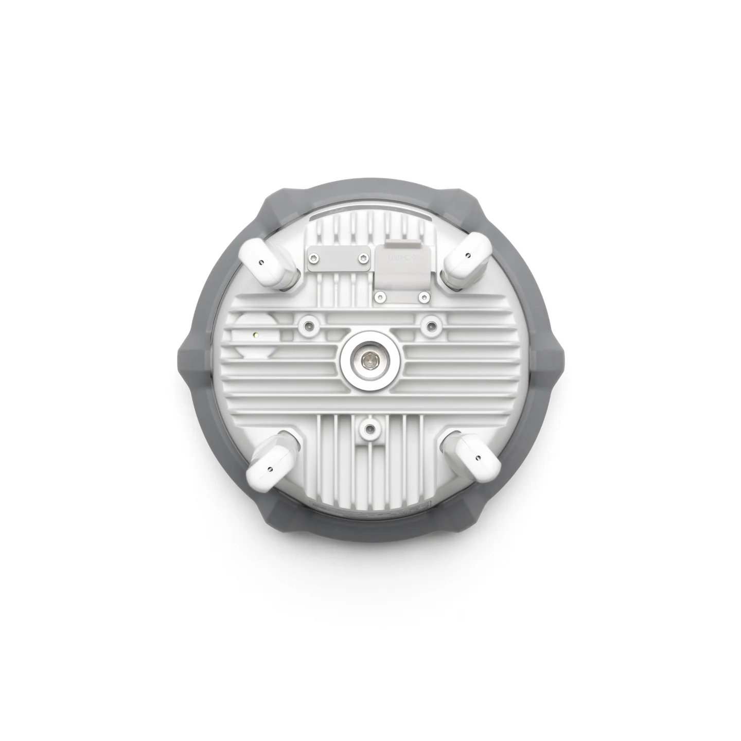
Rugged Field-Ready Design
Seamless Matrice 4 Integration
Centimetre-Level RTK Accuracy for Mapping & Automation
The D-RTK 3 delivers true centimetre-class positioning, enabling survey-grade accuracy for:
- Construction & engineering site mapping
- Repeatable automated flight routes
- Digital twins & high-accuracy photogrammetry
- Precision inspections for utilities and infrastructure
Essential for workflows that demand absolute positioning accuracy rather than GNSS estimates.
Multi-Constellation, Dual-Frequency GNSS for UK Environments
Designed for reliability in difficult GNSS conditions, the D-RTK 3 supports:
- GPS, Galileo, GLONASS, BeiDou multi-constellation tracking
- Dual-frequency RTK for fast fixing + stability
- Reduced drift and interference impact in urban or industrial sites
- Stable positioning near metal structures, cranes, substations & towers
Built for the UK’s mixed terrain — from cities to open rural landscapes.

Multi-Drone Broadcast Mode for Fleet Operations
The D-RTK 3 can simultaneously provide high-precision corrections to
multiple aircraft at once, enabling:
- Coordinated fleet surveys
- Multi-UAV inspection teams
- High-volume, time-critical mapping projects
- Synchronised flights for engineering & infrastructure audits
Perfect for organisations deploying multiple Matrice 4 drones in parallel.
Rugged, Field-Ready & Built for Demanding Deployments
Engineered for UK-ready field operations, the D-RTK 3 offers:
- IP-rated weather resistance for rain, dust & cold
- High-gain antenna for extended range
- Fast deployment for on-site surveying teams
- Stable operation in harsh industrial environments
Built to operate reliably on construction sites, farmland, coastlines and critical infrastructure locations.

Example UK Use Cases
Surveying & Mapping
High-accuracy site surveys, boundary mapping and construction modelling.
Infrastructure Inspection
Utilities, telecoms, rail and energy sector asset inspections.
Automated Flight Operations
Repeatable missions, digital twins, multi-drone workflows and fleet operations.
DJI D-RTK 3 Multifunctional Station — Frequently Asked Questions
What is the DJI D-RTK 3 Multifunctional Station and what does it do?
›
centimetre-level positioning accuracy for compatible enterprise drones.
It enhances mapping, surveying, inspections, automated flights and any workflow requiring
precision ground truthing.
It broadcasts live RTK correction data to aircraft such as the Matrice 4 Series, improving
positional accuracy far beyond standard GPS.
Which DJI aircraft are compatible with the D-RTK 3?
›
that support RTK correction.
It can connect to multiple drones at the same time, supporting fleet operations and
coordinated multi-aircraft missions.
How accurate is the D-RTK 3 in real-world UK environments?
›
accuracy.
It uses multi-constellation, dual-frequency GNSS (GPS, Galileo, BeiDou, GLONASS), helping maintain
stable accuracy around metal structures, cranes, rail lines and construction zones.
Does the D-RTK 3 support multiple drones at once?
›
multi-drone broadcast mode.
Ideal for:
• fleet inspections
• multi-aircraft mapping
• rapid large-area surveying
• coordinated engineering assessments
Do I need NTRIP or a mobile network when using the D-RTK 3?
›
It does not require a mobile network, internet connection or third-party correction service.
This makes it ideal for remote or rural UK areas where NTRIP coverage is unreliable.
What is the effective range of the D-RTK 3?
›
depending on terrain and line-of-sight.
Its dedicated antennas and strong transmission system offer more stable corrections than
network-based RTK in many locations.
Is the D-RTK 3 rugged enough for harsh field operations?
›
sites, coastal regions and agricultural fields.
Its durable build, reinforced antenna system and weather resistance ensure reliable performance
even in rain, wind and dust.
How fast can the D-RTK 3 be deployed?
›
Most teams achieve full RTK lock and drone connection within 2–3 minutes.
This makes it ideal for emergency response teams, mobile survey crews and short-notice field operations.
Which UK industries benefit most from using the D-RTK 3?
›
• construction & civil engineering
• surveying & geomatics
• rail & transport infrastructure
• utilities & telecoms inspection
• agriculture, forestry & land management
• emergency services & public safety
Any workflow requiring accuracy, repeatability and precision mapping benefits from RTK.
Do you provide UK setup, support and training for the D-RTK 3?
›
workflows.
This includes guidance on mapping accuracy, automated missions, NTRIP alternatives,
multi-drone RTK setups and Matrice 4 Series deployment.
DJI D-RTK 3 Multifunctional Station — Technical Specifications
Advanced RTK ground station designed for centimetre-level accuracy, fleet-scale operations,
and reliable GNSS correction in challenging UK environments. Ideal for mapping, surveying,
inspections and automated enterprise workflows.
Multi-Constellation GNSS
Dual-Frequency RTK
Multi-Drone Broadcast Mode
Long-Range Operation
Rugged Field-Ready Design
System Specifications
- Model: DJI D-RTK 3 Multifunctional Station
- Supported Aircraft: Matrice 4 Series + compatible DJI Enterprise platforms
- Positioning Type: Real-Time Kinematic (RTK) Correction
- Position Accuracy (RTK): Centimetre-level (horizontal & vertical)
- RTK Fix Time: Seconds (depending on satellite conditions)
- Supported Operating Modes: Base Station Mode, Broadcast Mode, Mobile Station Mode
- Max Connected Aircraft: Multiple (broadcast mode)
- Operating Frequency Bands: GNSS L1 / L2 dual-frequency
GNSS & Positioning
- Constellations Supported: GPS, Galileo, GLONASS, BeiDou
- Frequencies: L1 / L2 (multi-band tracking)
- Satellite Tracking: Multi-constellation, dual-frequency for high reliability
- Base-to-Aircraft Range: Capable of several kilometres (depending on terrain & LOS)
- Correction Link: DJI Proprietary Broadcast Transmission
- Multipath Resistance: Improved performance near metal structures & buildings
Hardware & Design
- Unit Type: Tripod-mounted GNSS RTK Base Station
- Build Quality: Rugged field-ready design
- Weather Protection: Resistant to rain, dust and harsh outdoor conditions
- Antennas: Integrated high-gain GNSS antennas
- Deployment Time: 2–3 minutes typical
- LED Status Indicators: GNSS, RTK status, broadcasting mode
Power & Connectivity
- Power Input: External AC power or field power supply
- Connectivity: Wireless RTK broadcast link
- Battery Support: Portable field power options depending on configuration
- Operating Time: Extended operation when using stable AC supply
Environmental & Operating Limits
- Operating Temperature: Typical outdoor UK operational range
- Weather Resistance: Designed for field deployment in mixed conditions
- Shock & Vibration: Built to withstand transport & on-site handling
- Ideal Deployment Areas: Construction sites, rail corridors, open fields, industrial areas
* Specifications represent typical performance. Values may vary based on environmental conditions,
satellite availability, elevation and deployment configuration.